
A completed map sits on the Seattle planner’s desk. Its line runs from Marker A to Marker B, continues to Marker C, and returns to the starting point. Elapsed time and distance appear beside the route, making the record look complete. Yet nothing on the page identifies whether an Android smartwatch with GPS, the connected phone, an assisted location service, or seller artwork produced the original position data.
The map is the final object, not the first proof. Before the planner trusts Candidate A’s GPS label, every hidden stage must be named: acquisition, recording, local storage, synchronization, and rendering. The Android Location Source Chain traces them backward to the route’s origin.

How to Verify an Android Smartwatch With GPS
Verify a GPS claim by separating four jobs that can occur on different devices: obtaining location, recording the session, transferring the record, and drawing the final map. A polished route image cannot identify its own source.
- Preserve the original GPS claim without accepting it as proof.
- Record the exact watch, Android phone, application, permissions, and connection states.
- Run a connected baseline to confirm that the complete system can produce a route.
- Remove the phone’s location contribution as completely as the documented setup permits.
- Require watch-side acquisition evidence and a local session before reconnection.
- Reconnect the phone and document the transfer.
- Label the application or service that renders the final map.
Buyers who have not narrowed the wider category should first use a broader Android smartwatch selection process. This diagnostic begins only after one candidate and one required route application have entered the shortlist.
Why the Completed Seattle Map Does Not Identify Its Source
The Marker A–B–C loop reveals that someone or something assembled a route record. It may also show a start time, stop time, distance, or line shape. None of those visible objects identifies the acquisition device.

Several chains could produce a similar result. The Android phone might supply the points while the watch acts as a remote control. Candidate A could receive assisted location, or the watch might acquire and retain the route before sending it to the phone. Seller artwork could imitate the same outcome without documenting any working process.
Watch architecture can narrow the possibilities without settling the result. The planner uses the four Android watch architectures to understand where applications and processing may reside, then demands evidence from the exact Candidate A setup.
Preserve the GPS Claim Before Running the Test
The planner creates a Claim-Origin Card before changing any settings. It records the current seller wording, available setup instructions, date of review, and the image or icon attached to the GPS statement.
| Claim object | What it can establish | What remains unproved |
|---|---|---|
| “GPS” label | The seller made a location-related claim | Acquisition device and operating conditions |
| Route artwork | A map is used in the presentation | Real recording, source, and accuracy |
| Watch-screen icon | An icon appears in the interface | Satellite acquisition or local storage |
| Setup description | A test route may be documented | Performance in the buyer’s exact environment |
Vague platform language needs a separate terminology check. The planner therefore reviews what an Android smartwatch label actually promises before converting the GPS wording into a testable source hypothesis.
Build One Privacy-Safe Seattle Route Record
The continuing example uses one familiar, permitted loop represented only as Marker A, Marker B, and Marker C. No coordinates, facility names, staff routes, maintenance sites, or security-sensitive details enter the notes.
This is a diagnostic route, not a navigation test. The planner already knows the loop and never relies on Candidate A for directions. Start and stop actions occur while stationary; during movement, neither device is touched or viewed. The test excludes cycling, street crossing, equipment carrying, and active field work.
Both the connected baseline and the source-isolation run use the same anonymous marker sequence. Keeping the route constant prevents a second example from weakening the evidence chain.
Record the Exact Android Location Environment
Before Marker A, the planner documents every component that could contribute to the route:
- Candidate A and its installed software;
- the exact Android phone environment;
- the route or companion application and version;
- watch and phone location permissions;
- Bluetooth, Wi-Fi, and cellular states where applicable;
- the phone’s location state;
- battery-saving or restricted-power states;
- the test date and starting battery observations.
Application identity comes before source testing. A buyer who has not confirmed the route should first verify the correct companion application. Candidate A also needs an exact Android environment certificate so that a later result can be reproduced instead of remembered vaguely.
Run the Phone-Assisted Baseline at Marker A
For the first run, the Android phone remains connected with its normal approved location route available. While stationary at Marker A, the planner starts Candidate A’s session and records what appears on both devices. The loop is completed without interaction, and the session ends only after returning to the stationary checkpoint.
A route appears in the Android application. That result proves that the complete connected system can produce a rendered record under the documented conditions. It does not show whether the phone, watch, or an assisted combination supplied the position data.
The baseline receives a deliberately narrow label:
Connected Route Produced — Origin Not Yet Isolated.
Separate a Connected GPS Result From Watch-Based GPS
The planner now writes four source hypotheses on the evidence sheet:
- Phone origin: the handset supplies the location data.
- Assisted watch session: Candidate A controls or stores the activity while the phone contributes location.
- Watch origin: Candidate A acquires and records the route before phone return.
- Origin unresolved: the available evidence cannot distinguish the path.
A watch display does not decide among them, and neither does a phone-disconnected symbol. Buyers who need broader operation away from the handset should separately define an Android independence boundary; this article isolates only one route source.
Prove Watch-Side Acquisition Before Movement Begins
During the second run, the planner removes the phone’s contribution as completely as Candidate A’s documented setup allows. Every changed connection and location state is written down. The phone is not merely placed in a pocket while remaining an unidentified source.
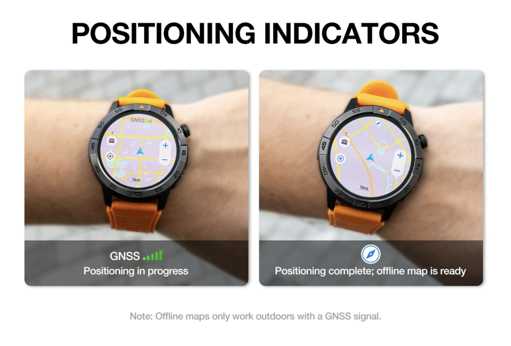
At Marker A, Candidate A must produce stronger evidence than a generic GPS icon. The preferred hierarchy is:
- real-time watch-side GNSS or chipset status;
- a documented satellite-acquisition state whose meaning is verified;
- phone-independent acquisition supported by current onboard-location documentation;
- a generic icon or unlabeled status.
The fourth level cannot earn a watch-origin pass. When Candidate A exposes explicit watch-side acquisition evidence, the planner records the state and time without publishing coordinates.
Required application behavior still deserves its own check. A route button or local summary does not prove every expected action, so buyers with a broader portfolio should confirm coverage for their essential application actions.
Complete the Seattle Loop Without Watch Interaction
Once the acquisition receipt is recorded, the planner begins the Marker A–B–C loop. Candidate A remains untouched between the stationary start and finish points.
After returning to Marker A, the planner stops and reviews the session while stationary. The route shape is not compared with a survey, phone track, or visual expectation. A smooth line would not prove accuracy, while an irregular line would not by itself identify the source.
Require a Local Route Record Before Android Sync
Before the phone returns, Candidate A must show that the completed session exists locally. A convincing pre-sync record may include the start and stop time, a local session identifier, a route summary, or another documented object that distinguishes this loop from a generic activity screen.
Nothing is inferred from a check mark alone. If the watch shows no identifiable session until reconnection, recorder authority remains unresolved. Candidate A passes this gate because the Marker A–B–C session appears locally before the Android handset is restored.
The planner captures a privacy-safe Local-Record Receipt containing:
- the anonymous route-session label;
- start and stop timestamps;
- the documented acquisition state;
- the watch-local record state;
- confirmation that the phone has not yet rejoined.
Reconnect the Android Phone and Label the Handoff
Only after the local receipt is complete does the planner restore the documented phone connection. The evidence card records the reconnection time, when synchronization begins, which application receives the session, and whether the watch-local record remains visible.
Candidate A’s route appears in the Android application after the handoff. That transfer supports the source chain, but one successful route sync cannot establish broad reconnection reliability. Repeated recovery after restarts, range loss, and application closure belongs in a separate Android reconnection recovery drill.
Identify Which Application Renders the Final Map
The planner compares the pre-sync watch record with the post-sync Android display. Candidate A stored the session locally, while the phone application drew the Marker A–B–C line after transfer. Acquisition, recording, and rendering therefore belong to different stages.
A cloud or account service could add another destination in a different environment. When that stage exists, it must be labeled rather than folded invisibly into “the app.” The final authority card should name where the route remains after the test and how its session identifier relates to the watch-local record.
Compare the Four Possible Location Chains
| Source hypothesis | Acquisition evidence | Local pre-sync record | Phone role during route | Final renderer | Result |
|---|---|---|---|---|---|
| Seller artwork | None | None | Unknown | Seller image | Rejected |
| Phone-origin route | Phone-side or unresolved | No watch-local proof | Location source | Phone application | Phone origin |
| Assisted watch session | Mixed or unresolved | Possible | Contributes location | Phone application | Assisted source |
| Watch-origin route | Explicit watch-side evidence | Confirmed | Removed during route | Phone application after sync | Source verified |
Candidate A follows the final chain. Its result does not come from the attractiveness of the map; it comes from the acquisition receipt, local record, timed handoff, and labeled renderer.
Issue the Seattle Location-Source Verdict
The completed evidence chain shows that Candidate A produced explicit watch-side acquisition evidence at Marker A. Before the phone returned, the wearable retained an identifiable session for the full loop. Android synchronization occurred afterward, and the receiving phone application rendered the final map.
The buyer-specific verdict is:
Source-Verified Watch-Origin Record — Candidate A Logs the Seattle Test Loop Before Android Sync and Phone-Side Rendering.
This result applies only to the documented Candidate A environment, application, permissions, connection states, power state, software, route session, and test date. It does not establish route accuracy, navigation quality, emergency reliability, live tracking, future support, or performance on another Android phone.
Correct Seven GPS Source Mistakes
1. Treating a Map Image as Hardware Proof
A route image shows a rendered output. It does not identify the device that acquired or recorded the points.
2. Treating a GPS Icon as Satellite Acquisition
An icon needs a documented meaning. Without stronger evidence, the acquisition source remains unresolved.
3. Assuming the Displaying Device Recorded the Route
The watch may display a phone-started session, and the phone may render a watch-recorded one.
4. Assuming Phone Absence Proves GNSS Origin
Removing the handset reduces one possible contribution. Watch-side acquisition still needs its own evidence.
5. Reconnecting Before Checking Local Storage
An early reconnection destroys the clean boundary between local recording and later synchronization.
6. Calling Synchronization the Same Thing as Recording
Transfer moves an existing record. It does not reveal who originally created it unless the earlier stages were documented.
7. Judging Accuracy Before Identifying the Source
Accuracy is a separate investigation. First establish which device and service produced the record being evaluated.
Questions U.S. Buyers Ask About Android GPS Watches
Does Built-In GPS Mean Every Application Uses the Watch Receiver?
No universal assumption is safe. Test the exact application, permissions, connection state, and watch environment.
Does a Route Recorded Without the Phone Prove Satellite Acquisition?
Not by itself. It supports reduced phone dependence, but the watch still needs explicit acquisition evidence.
Can the Phone Draw a Map From a Watch-Recorded Route?
Yes. The source chain can assign acquisition and local recording to the watch while the Android application handles synchronization and rendering.
Does a Clean Route Line Prove GPS Accuracy?
No. A visually convincing line cannot establish source, measurement error, repeatability, or performance under different conditions.
What if the Watch Shows a Summary but No Route Before Sync?
Record exactly what exists. When the local object cannot be linked to the later route, the recorder or route origin remains unresolved.
Should This Test Be Used for Emergency Navigation?
No. The Marker A–B–C loop is a controlled source diagnostic, not evidence of emergency, rescue, medical, or personal-safety reliability.
Trace Every Stage Before Trusting the GPS Label
The opening Seattle map looked complete because the route line hid the machinery behind it. Once the planner traced the chain, each stage received a separate label: Candidate A supplied the documented watch-side acquisition evidence, stored the loop locally, transferred the session after reconnection, and left the phone application to render the final map.
That sequence supports a watch-origin verdict for one controlled record. It cannot prove accuracy, navigation quality, safety performance, long-term reliability, or identical behavior after a software or application change. A buyer should trust the documented source chain—not the visual confidence of a completed map.
Before evaluating this smartwatch product candidate, treat every GPS label and map image as unverified, then identify the acquisition source, local record, Android handoff, and final renderer independently.